No Noise Complaints from Fingal Head have been recorded recently November 25 to January 26 and this means that no noise complaints have been registered to Fingal Head residents in well over 12 months.
Tweed Shire Council resolved in 2024 “that a Community Climate Action group be established to enable active community involvement from Tweed residents in responding to climate change and driving local climate change solutions
The Advisory Committee acts as the primary liaison between the project and the community, facilitating consultation and providing advice on operations, ensuring stakeholder input is considered in managing sand delivery and environmental impacts.
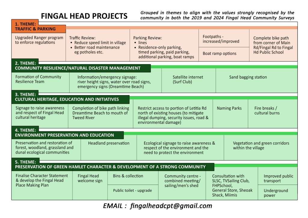
The 2024 Fingal Head Community Survey identified several projects that support the preservation of the unique character of Fingal Head. These projects have been organised to align with the six values strongly recognised by the community in both the 2019 and 2024 Fingal Head Community Surveys.
It is proposed to form Community Initiative Groups (CIGs) to focus on and implement these projects. If you are interested in any aspect of any of these projects, please consider joining one or more of these CIGs and expressing your interest by emailing fingalheadcpt@gmail.com or attending the FHCA General Meeting on November 19. The main agenda item for the meeting will be the formation of the Community Interest Groups (CIGS) to implement the various projects and all members of the community are welcome to attend.
This is your opportunity to contribute to your community and help ‘Keep Fingal Special.’
The Fingal Head Planning Team (FHCPT) revisited the 2019 Fingal Head Locality Plan to develop the Fingal Head Vision and Values Statement. Subsequently, they surveyed the Fingal Head community in 2024.
The Fingal Head Community Vision Statement
The Fingal Head Community Values
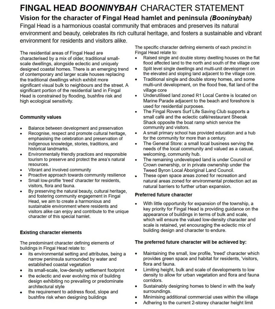
The Fingal Head Character Statement
The FHCPT analysed and compiled the results of this 2024 Community Survey and provided the information to the TSC Strategic Planning Team. The Character Statement below was developed by TSC and presented to the Fingal Head community during two information sessions on 10th and 26th July. This document is included in the TSC Draft Development Control Plan and is now open for comment on the TSC ‘Your Say Tweed’ online platform until 3 December (see link below).
Since this was based on community input, please ensure you inform the Council that you support it.
The Fingal Flyer, a FHCA Publication compiling community input from all sources. Published by the FHCA, printed by the Fingal Head Primary School and distributed by members of the FHCA.
The Fingal Head Community Association investigated recent historical flooding events that have occurred in our Fingal Head Community in northern Rivers New South Wales as part of our Community Resilience Initiative.
The river flood data required was provided by the Bureau of Meteorology, in accordance with the FOI Act relating the historical River Height data for the:
1. Tweed River at Chinderah (mAHD) – Station number 558010 2. Tweed River at Tumbulgum (mAHD) – Station Number 558014
For the periods:
Cyclone Debbie from the period 10am March 30, 2017 to 10am April 2, 2017
Major rain bomb event in northern rivers from the period 10am Saturday February 26, 2022 to 10am Friday March 4, 2022
Additional river flood data has been provided by the Tweed Shire Council using data sourced from Manly Hydraulics P/L